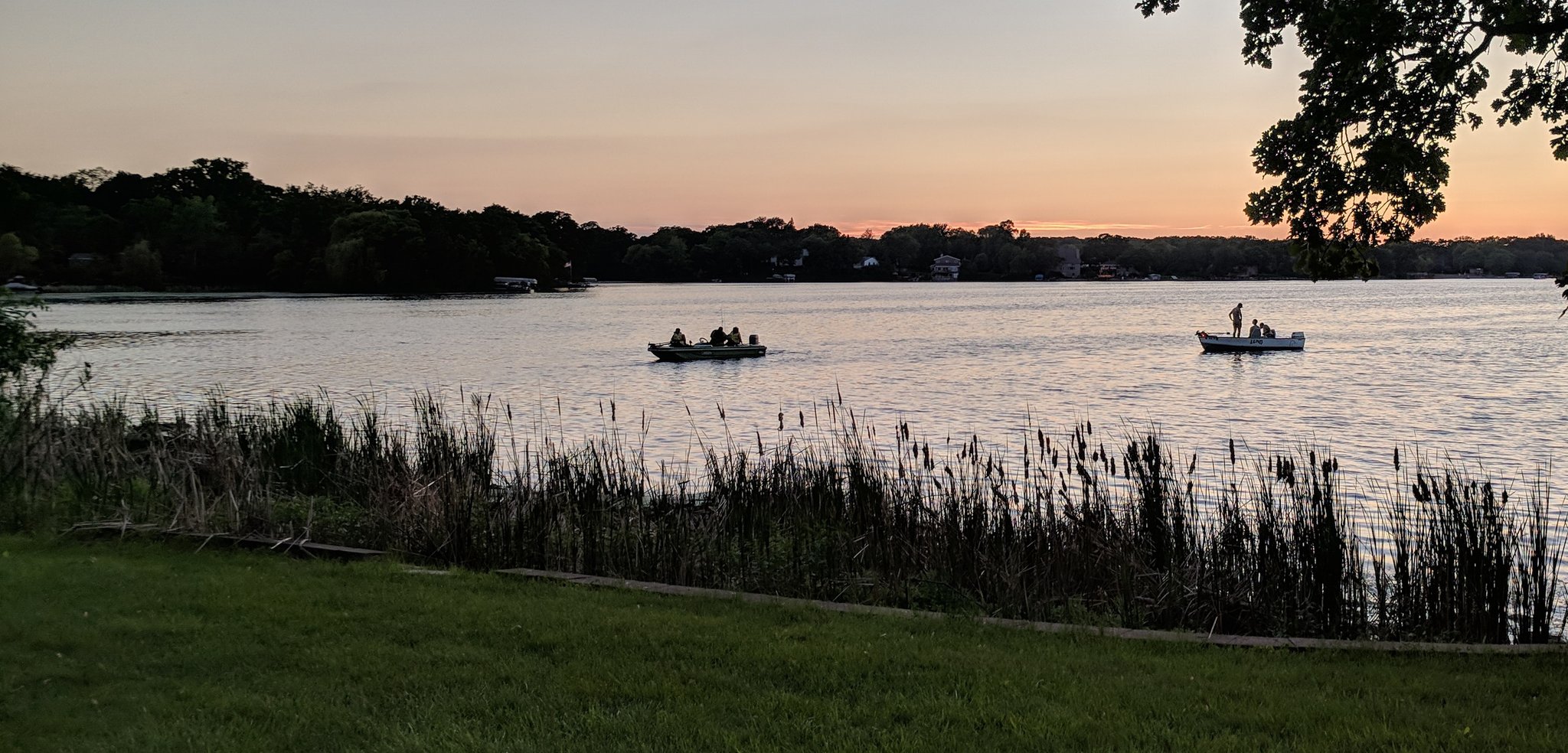
On a warm September afternoon, sunny and calm and a blue-ribbon day for golf, I drive south on I-35E, through Burnsville, past the freeway’s east-west merger onto I-35, past Buck Hill, take the next exit and find myself in Lakeville.
I hop off the freeway, head south a half-mile, and pull into the spot where the clubhouse is.
Or was, I guess.
I know it should be here, on this very spot, because I have studied this area closely online for more than a year.
Only … no clubhouse. Instead, the sign on the door reads:
“Chipotle.”
Thrown off, I stop to regroup. I walk in the door and stride up to the counter.
Me: “Can I just have a small soda?”
Worker: “Two dollars and four cents.”
Me: “And the 2:44 tee time.”
Pause.
Worker: “Sorry?”
Me: “Never mind.”
I got the soda. Not the tee time.
Then again, no one ever did.
Here is an aerial view of 17599 Kenwood Trail in Lakeville, home to the burrito bowls and carnitas of Chipotle Mexican Grill. Red “C” marks the spot:

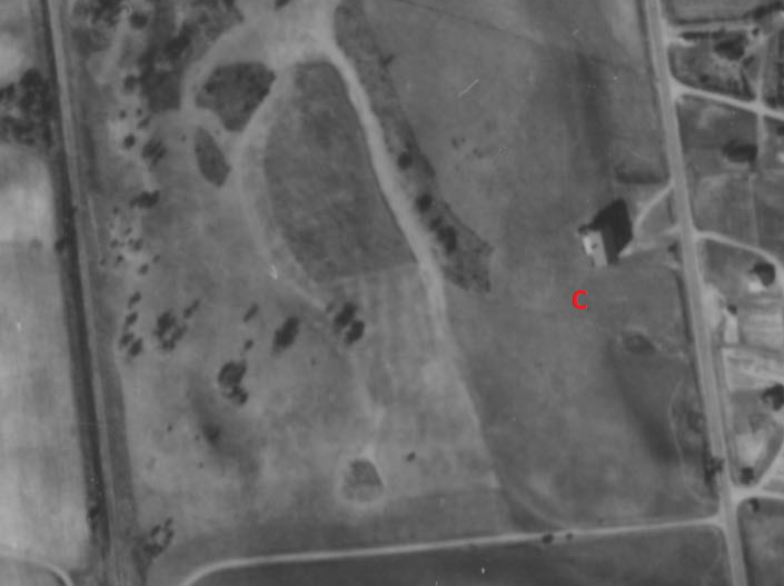
Below is the same spot, some years earlier. Seventy-three years earlier, to be precise. Again, red “C” marks the spot in this 1945 aerial photo. Only this time, “C” does not stand for Chipotle:
And below one more time, a 1927 newspaper ad promoting development of the immediate area. This time, there is an inscription next to the red “C”. Inscription reads “Golf Club House.”
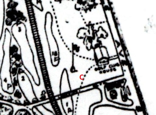
This, just to the west of the flagpole, was to be the point of departure for 18 holes at Orchard Beach and Golf Club in northwestern Lakeville. But the flag, it is presumed, was never raised, and Orchard Beach instead ranks as the most unheard-of and mysterious lost-golf course site (almost-lost, to be perfectly accurate) I have come across.
A larger look at what was to be Orchard Beach and Golf Club:
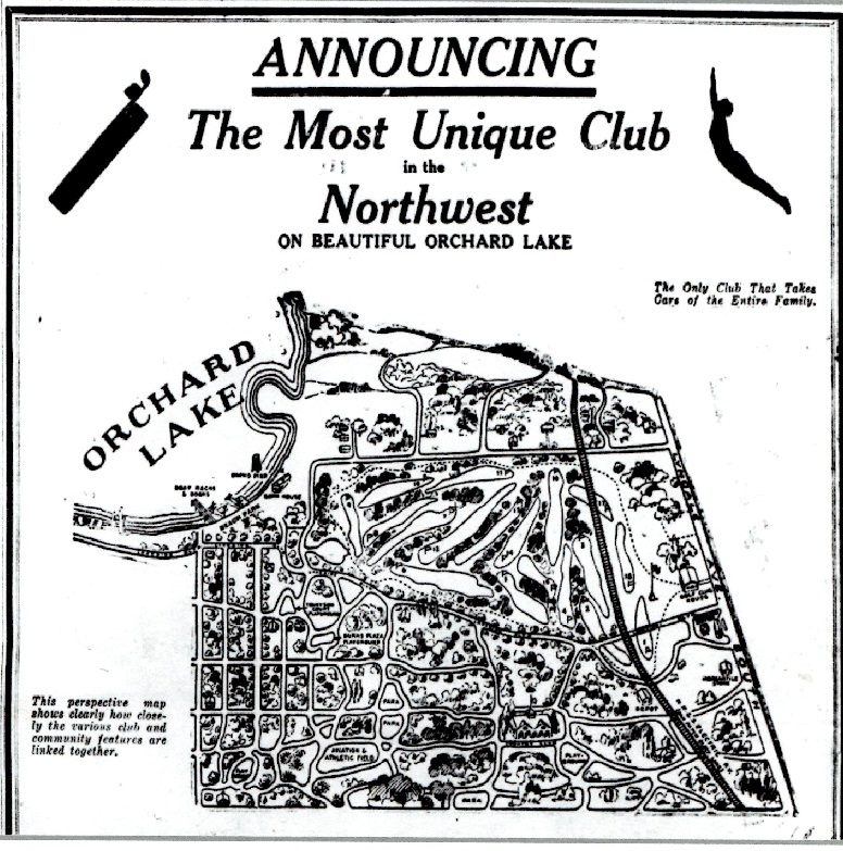
This is the top portion of an advertisement that appeared in the June 11, 1927, issue of the Minneapolis Tribune. The ad occupied two-thirds of a page. You can click on it to see more detail.
The preceding October, another ad had appeared in the Tribune. “Orchard Beach and Golf Club,” read the large type. In smaller type, the ad crowed: “The Most FASCINATING and SCENIC PLAYGROUND That Has Ever Been Opened to the Public.”
Hyperbole has always been a staple in golf-course promotion. This was hyperbole on Roaring Twenties steroids.
The crowing added up to a veritable din when weighed with the full ad:
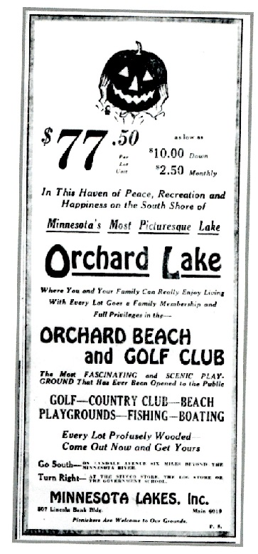
These ads were just two in a series that blitzed readers of the Minneapolis Tribune in 1926 and ’27 — at least nine large display ads in June and July of 1927, plus a handful from earlier in ’27 used to recruit a sales force. Orchard Beach and Golf Club, the ads suggested, would be nothing like Twin Citians had ever seen. And it wasn’t just golf and a lake that were proffered to reader/buyers. Other ads and newspaper stories promised tennis, playgrounds, an athletic field, parks, an aviation field and a large residential development — all situated, according to an October 1926 ad, “amid rolling hills generously wooded with the virgin growth of beautiful hardwood trees and a myriad of the various wild flowers painted by Dame Nature.”
OK then.
Orchard Beach — the club, golf course and housing development — was to have encompassed an area that is loosely bordered, in 2018 terms, by Kenwood Trail on the east, 172nd Street West on the north, the southeast corner of Orchard Lake on the  northwest and 185th Street West on the south. The western border likely includes parts of at least three holes on what is now Brackett’s Crossing Country Club (nee Honeywell Country Club, established in 1961). Within those proposed Orchard Beach and Golf Club confines, there is now a large, upscale residential area to the immediate east and northeast of Brackett’s Crossing, including Prairie Lake Park; the Queen Anne Courts mobile home neighborhood; and a less densely developed section of homes and hobby farm-ish land along 172nd Street and near Orchard Lake. Orchard Beach’s golf course was to be built mostly in the latter two areas.
But the surf ‘n’ turf that was to be Orchard Beach and Golf Club never quite worked out. No tee time was ever reserved, no ace served, no seesaw seen, no aerial landing landed. I can find no documentation of the project dating to 1928 or later, and the project is so unknown that one might as well suggest the Loch Ness monster once inhabited Orchard Lake as to suggest there ever were big plans for the neighborhood. I contacted or tried to contact three historical societies, one courthouse and at least a dozen residents or former residents of the area, including at least three parties who live smack-dab on top of what was to be the golf course, and never heard so much as a whisper of knowledge of the Orchard Beach project.
Yet the current lie of the land indicates site work was started, and documents confirm it.
“A sporty 18 hole golf course is under construction,” read part of a June 1927 ad in the Minneapolis Tribune. That same month, the Tribune ran a story headlined “Orchard Club Will Feature Recreation.”
“Approximately 1,000 acres of land are being developed for the Orchard Beach and Golf Club, on Lyndale avenue south, 17 miles from Minneapolis,” the story read. “The project is planned as one of the most completely equipped private recreational grounds in the northwest. The work has been under way since last fall.”
Orchard Beach would not have been Lakeville’s first golf course. The 1920s marked the heyday of golf at Antlers Park Golf Links, an offshoot of the popular Antlers Park Amusement Park owned by George O’Rourke on the southeastern shore of Lake Marion, only three miles southeast of Orchard Lake. In August 1927, as construction of the Orchard Beach course presumably was underway, the Dakota County Tribune ran a story under the headline “Antlers Golf Course Is Attracting More City Artists,” and noting the Antlers Park course had been expanded from nine to 18 holes. (The Antlers Park course closed in 1938.)
It’s likely that Antlers Park and Orchard Beach would not have been direct competitors. Antlers was a public course, while Orchard Beach would presumably have been private, limited to paying members of the club, or perhaps open to the public but at a higher greens fee.
————————–
Orchard Beach and Golf Club is, to steal without apologies to Sir Winston Churchill, a riddle wrapped in a mystery inside an enigma. It’s 99 percent certain that the project started, but it’s even more certain it was never finished. As with any worth-its-salt mystery, clues have been left. Some are stored in aerial photos.
What follows is something of a time-lapse sequence of the area southwest of Orchard Lake, i.e. the proposed home to Orchard Beach and Golf Club. No aerial photos before the mid-1930s are readily available, so the 1927 proposed development, shown earlier, can be used as the earliest reference point.
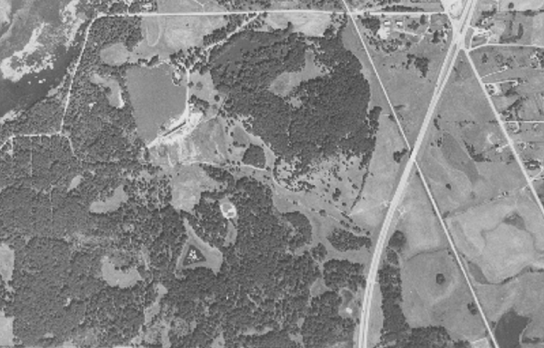
In 1937, this is how the area looked. Though the Orchard Beach project had presumably been abandoned for a decade by then, clear signs of it remain. I marked the general confines of the proposed development with a red border and letter-coded other notable landmarks, either likely or speculative. (All but one aerial photo in this post are courtesy of the University of Minnesota’s John Borchert Map Library. Click on the images for closer looks.)
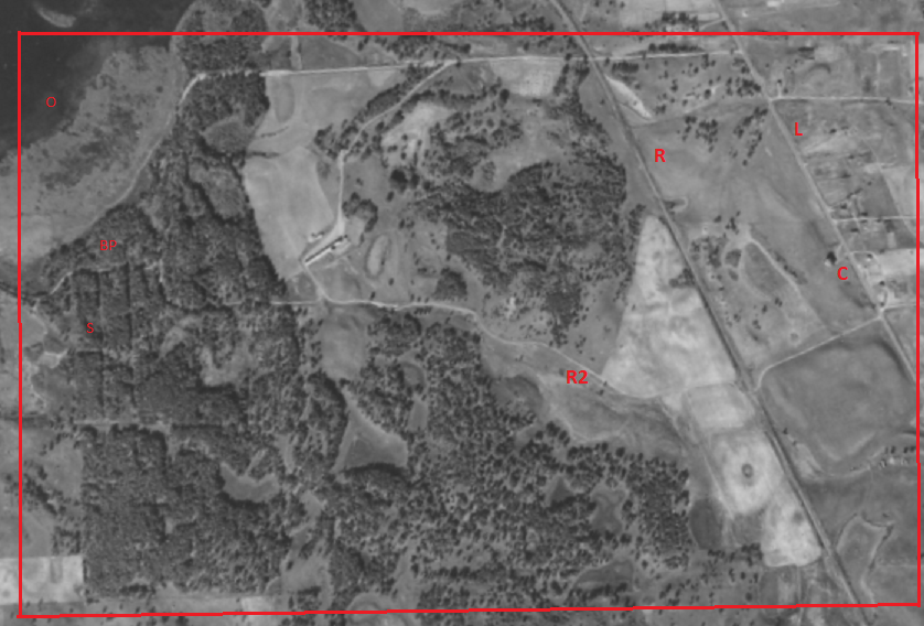
L — Lyndale Avenue. At the time, this was the main drag out of downtown Minneapolis, through Bloomington, across the Minnesota River and south to Lakeville.
R – Railroad. This was the Minneapolis Northfield and Southern Railway. In the 1920s, it was known as the Dan Patch Railroad, an electric and then steam line whose stops included Antlers Park.
C – Orchard Beach and Golf Club clubhouse. I have no verification that this building was in fact the clubhouse, but its location is a near-exact match with the drawing in the 1927 Minneapolis Tribune ad.
R2 – Road. And nothing more, really, except one of the clearest indications that work had been done on the Orchard Beach development. The road marked the southern edge of the proposed golf course, traveled west, turned north, and eventually connected with 172nd Street West. In the 1927 ad, the road can clearly be seen cutting through the middle of the proposed development.
O and BP — Orchard Lake and what the developers dubbed Orchard Lake Beach Park. Today, Orchard Beach Park lies in almost exactly the same place.
S – Streets — or, more accurately, proposed streets. Compare the pattern of rectangles with the same in the Tribune ad. No houses are apparent along these rectangular lines, but the lines do indicate that land was cleared for the purpose of putting in streets.
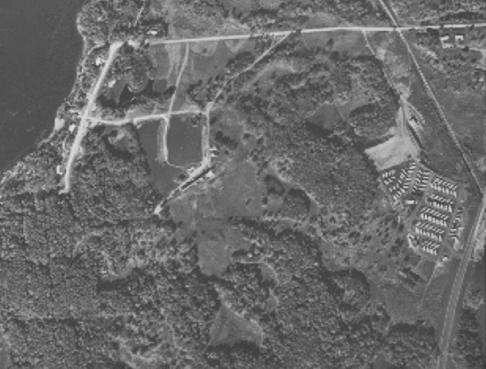
Moving along to 1945:
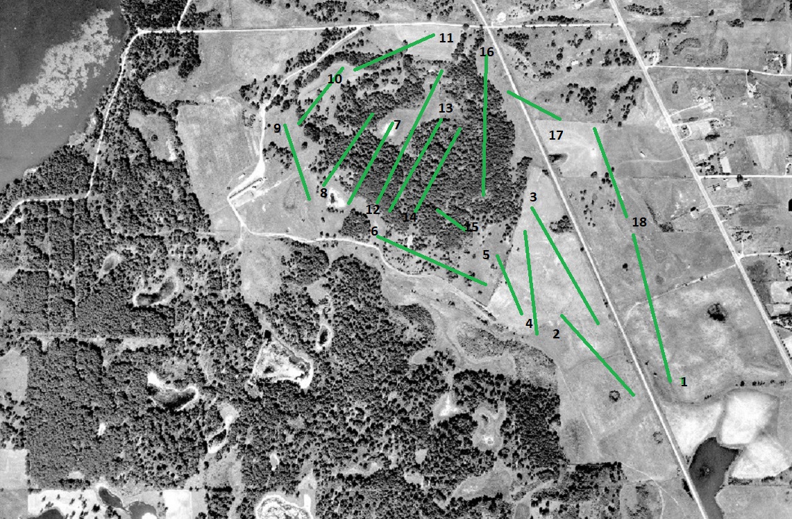
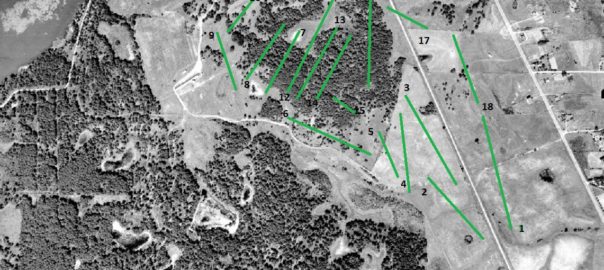
What’s notable in the eight years since the 1937 photo? Not all that much, except for notable improvement in the resolution of aerial photography. But this land stayed largely the same, except for more development to the east of Lyndale Avenue. This photo lends veracity to the notion that land had been cleared almost 20 years earlier for the purposes of building a golf course. I sketched the proposed routing on this photo, in green lines that correspond to the 1927 drawing. Best guess is that land was cleared for about half the course in 1926 and ’27 before the project was stopped for unknown reasons. This sketched routing is entirely plausible for the path of a reputable 18-hole golf course, and an accomplished (not renowned) golfer was hired to design the course. I will post more about the project’s principals shortly.
Click for a larger look at the photo and see if you know anyone who might have lived on one of these “holes.”
By 1957 (below), U.S. Highway 65 had been built; it cut through the southeastern corner of what was to be Orchard Beach and Golf Club. Within a decade, the route would become I-35:
A look at 1964:
A few more roads had been built near Orchard Lake; the road that cut through the south side of the property had effectively disappeared; and, most notably, the mobile home park now known as Queen Anne Courts had been built near I-35, between Lyndale Avenue and the defunct railroad line.
Finally, 2018 (U.S. Geological Survey photo):
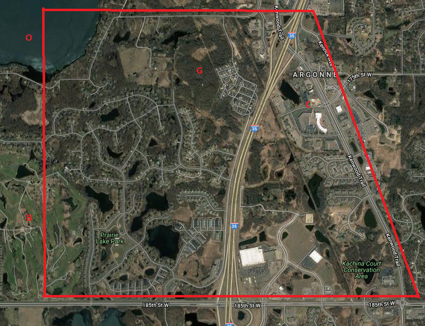
O – Orchard Lake
G – Area of proposed Orchard Beach golf course
B – Brackett’s Crossing Country Club
C – Chipotle/Orchard Beach and Golf Club clubhouse
Next post: The people behind Orchard Beach and Golf Club and the mystery of its demise.
Latest posts by Joe Bissen (see all)
- Another lost routing: Hilltop, Columbia Heights - June 19, 2024
- Two lost routes: First, Antlers Park - June 17, 2024
- Tree trouble and townball: Naeseth Country Club, Wanamingo - May 6, 2024