
If the city of St. Cloud is the heart of our excursion through Central Minnesota lost-golf course country, state Highway 23 is the aorta — the main artery.
Of the 12 lost courses I know of within 30 miles of St. Cloud, 11 of them lie within six miles of 23, the highway that cuts diagonally through Minnesota and stretches 341 miles from Pipestone to Duluth, at one point bisecting St. Cloud. Two of those lost courses are/were within easy earshot of the highway. You know, close enough so that you could have driven past and done something really hilarious like shouting “Fore!” at the top of your lungs. (Or you could have shouted “Fore! You’ll soon be gone!” That might not have been funny, but it would have been spectacularly prescient.)
At any rate, we’ve covered St. Cloud Golf Club, plus Hillside and Wildwood, all Highway 23 neighbors. Another was the three-holer at Rockville, which I’m not counting as a lost course.
I’ll make St. Cloud the starting point for a look at three more lost courses. As before, each course gets a numeric designation as I approach having identified 200 Minnesota lost golf courses.
Springbrook, St. Augusta (established 1930; lost course No. 193)
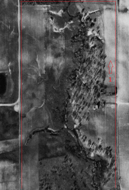
East of Rockville (and south of St. Cloud) lies the city of St. Augusta. The city’s downtown is at its northeastern corner, next to I-94, but the entirety of the city sprawls across 30 square miles. In the north-central part of the city, not quite a mile north of the St. Augusta Fire Department headquarters and coincidentally the Hidden Lake Disc Golf Course, is a site upon which the targets were not steel baskets but 4 1/4-inch holes in the ground.
“St. Cloud’s first public golf course, Springbrook, will be formally opened next Saturday and Sunday,” the St. Cloud Times reported on April 30, 1930. “The name of the new course implies it’s (sic) natural beauties. A little trout brook meanders through the entire property, necessitating two crossings during the course of a single round. Five pure water springs, giving up nearly ice cold water, are situated so that they are but a short distance from each of the nine holes.
“… Starting from the farm house on the coure (sic), the first hole is directly north, some 400 yards. The second hole requires crossing the brook across a deep gully.”
Further description followed. The course was built on land owned by Charles H. Tanner, who, according to other Times stories, was vice president of Northwestern Oil Company and a St. Cloud Country Club member. Tanner’s wife, Jessie, was mentioned in the Times society pages for doing things like making presentations on India’s caste system. The Tanners lived in St. Cloud and — best guess — probably leased the St. Augusta farm. In the 1930 Times story, it was reported that Mr. and Mrs. Leo Schaefer lived on the farm and would be the golf course caretakers.
Tanner’s farm covered 80 acres at what is now the intersection of County Roads 136 and 115. The farmhouse was on the eastern side of the grounds, with the first hole headed north, as mentioned, probably to the edge of what is now County 115, which took a slightly different path in the 1930s. Tanner’s farm extended south, its likely boundary lying where the northern edge of the Robins Brook Estates development is today.
Tanner enlisted a “Chicago expert” more than a year before the course was established to lay out the course, the Times reported, and “the expert was enthusiastic over the natural possibilities offered by the Tanner farm.” I read this and immediately speculated that the expert might have been Tom Bendelow, a Chicago course architect who designed between 500 and 1,000 U.S. courses and was known as the “Johnny Appleseed of American golf.” But that seems unlikely, because Bendelow had done most of his work well before 1929.
Springbrook (called Spring Brook in some stories) had sand greens, and a picnic area was planned for the grounds. Tanner declined to offer memberships and made course strictly daily-fee. The Schaefers would set up a “refreshment parlor and serve chicken dinners to the golfers and others,” the Times story stated.
Springbrook underwent an uncommon transformation in 1932 with the conversion of sand greens to grass. Most small-town courses in Minnesota in that era featured sand greens because of the relatively prohibitive cost of establishing and maintaining grass greens. The Schaefers apparently were gone by 1932, because the course “Is under new management this year and new patrons are always welcome so long as the rules of the course are observed,” the St. Cloud Times reported on June 4, 1932.
My best guess is that the course didn’t last long past 1932. A real estate transaction in a Times issue suggested that the Tanners sold their farm in 1937, and Charles Tanner died later that year. A 1938 aerial photo of the property offers only vague golf-course forms, suggesting the course had been abandoned years before.
Scenic, Cold Spring (1930; lost course No. 194)
Cold Spring has two existing golf courses — River Oaks, just northeast of downtown and established in 1990, and Rich-Spring (1962), southwest of downtown and — natch — adjacent to Highway 23. (“Fore! Not gone! Good job!”)
The one-time existence of a separate, third course just outside the city limits came pretty much as a what-are-you-crazy surprise to a half-dozen Cold Spring residents I talked with.
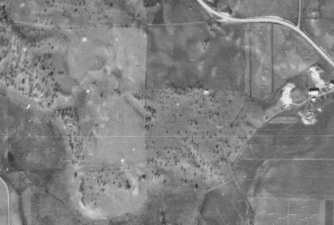
Cold Spring Golf Club was organized in 1930, and a seven-hole course was organized in Wakefield Township, 1.3 miles northwest of downtown and seven-tenths of a mile northwest of where Rocori High School is today. The course took up a square plot between where today 163rd Avenue turns into 238th street and County Highway 50, though the golf grounds did not reach the highway.
The original club occupied a plot owned by John DeWenter (spelled that by the St. Cloud Times, spelled De Winter on a 1925 plat map). In 1931, the club leased 19 additional acres from Harry Thelen that was used to build two more holes. (Caveat: I can’t unequivocally say this is where the golf course was, as De Winter and Thelen both owned land elsewhere in Wakefield Township, but this was the only place in which the lots abutted, and aerial photographs strongly indicate the one-time existence of a golf course there.)
On April 8, 1931, a St. Cloud Times story indicated that the golf club had appropriated itself with the name “Scenic Golf course.” The Times followed with a grammatical Freudian slip: “The typography of the new land is admirably suited to add snap to the course,” the story read. Ed Honer was hired as course caretaker, and memberships were set at $5 for men and $3 for women and children.
The Cold Spring club faced Albany in a match later in 1931. In 1932, two holes were changed, and several bunkers were added around two greens.
A playing highlight of dubious sorts occurred on May 3, 1936. The Times reported on it the next day. “Ferdinand Peters, president of the Cold Spring Golf club, ‘showed the boys how it was done’ Sunday afternoon when he teed off and his ball struck a swallow. The bird was instantly killed, much to Mr. Peters’ regret, but nevertheless he could not resist the opportunity to ‘Ripley’ the other golfers.”
If the “Ripley” reference escapes you, you must be younger than 50. Google “Ripley’s Believe It Or Not.”
The golf course likely closed down shortly after Peters’ bird-but-not-a-birdie. A 1938 aerial photo of the area suggested that some of the green sites, which usually are distinct on aerials, had softened around their edges, and I could not find any references to Cold Spring Golf club in the 1939 issues of the Cold Spring Record.
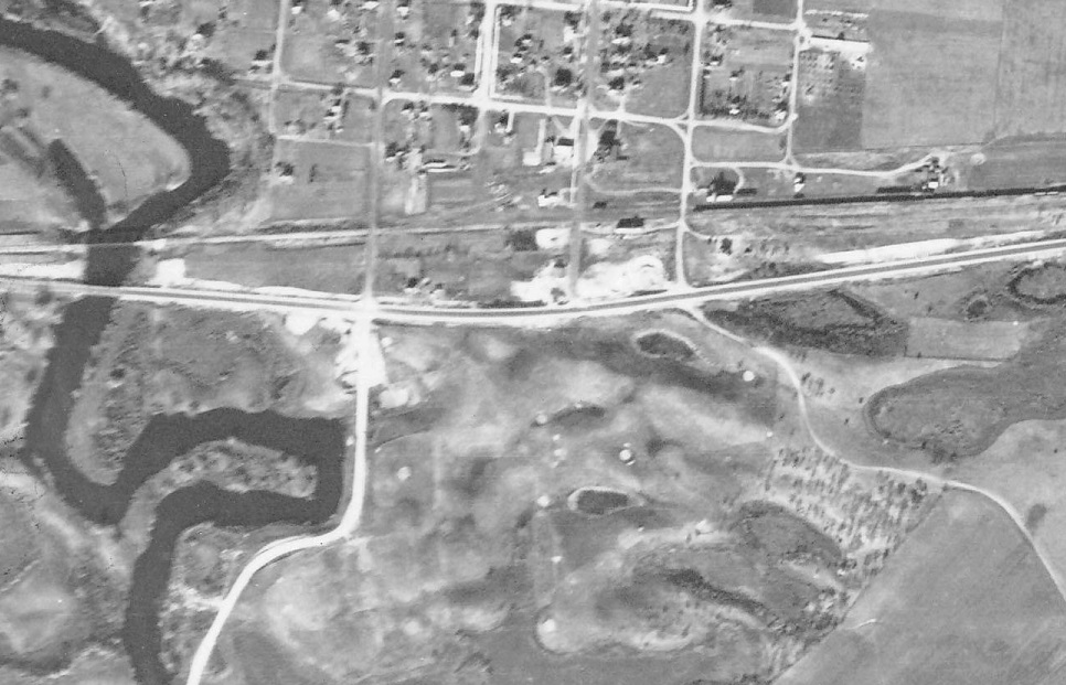
Chain O’ Lakes, Richmond (1931; lost course No. 195)
The 1929-31 Stearns County golf boom continued farther west with the establishment of a course in Richmond.
“The Chain O’ Lakes Golf course opened last Sunday to the public and a full nine-hole course is now available to the public. The course is described as one of the finest in this section of the country,” the St. Cloud Times reported on May 15, 1931.
The course was situated just off Highway 23 at the southern edge of Richmond, where Minnesota 22 headed south to Eden Valley. The course underwent a significant overhaul in 1933, with every green “rebuilt entirely,” the Times reported, “being made much larger and constructed so as to respond to the accuracy designable to the best golfers.” It was not mentioned whether the greens were sand or grass, though the overhaul resulted in greens of “various shapes,” which would have been highly unusual for a sand-greens course.
In 1935, Dr. E.M. Reichert was elected club president. Annual membership was $3 for men and $1.50, and a greens fee of 25 cents was set. Fees remained the same at least through 1935, when Alois J. Lang was elected president. The course was described as par-32, with a length of 3,205 yards (that’s a long course for par 32).
The Chain O’ Lakes course’s end date is unknown. Though a file at the Stearns County Museum suggests it was abandoned in 1939, a 1941 Times news story mentioned the golf course as though it still were operating. I was able to track down Richmond-area residents who remembered the existence of the course but couldn’t offer details or say when it might have closed.
Next: Back to St. Cloud and nearby.
Latest posts by Joe Bissen (see all)
- Another lost routing: Hilltop, Columbia Heights - June 19, 2024
- Two lost routes: First, Antlers Park - June 17, 2024
- Tree trouble and townball: Naeseth Country Club, Wanamingo - May 6, 2024